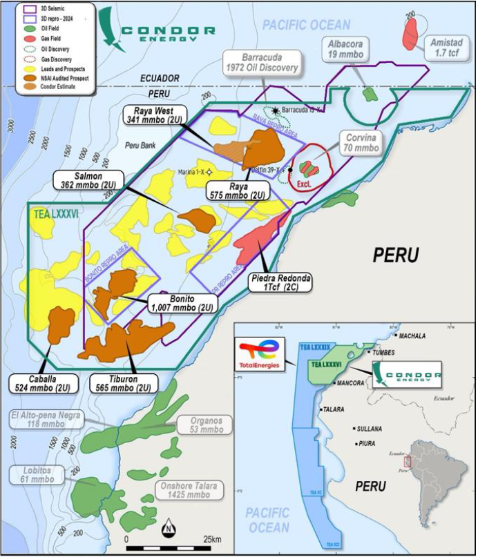
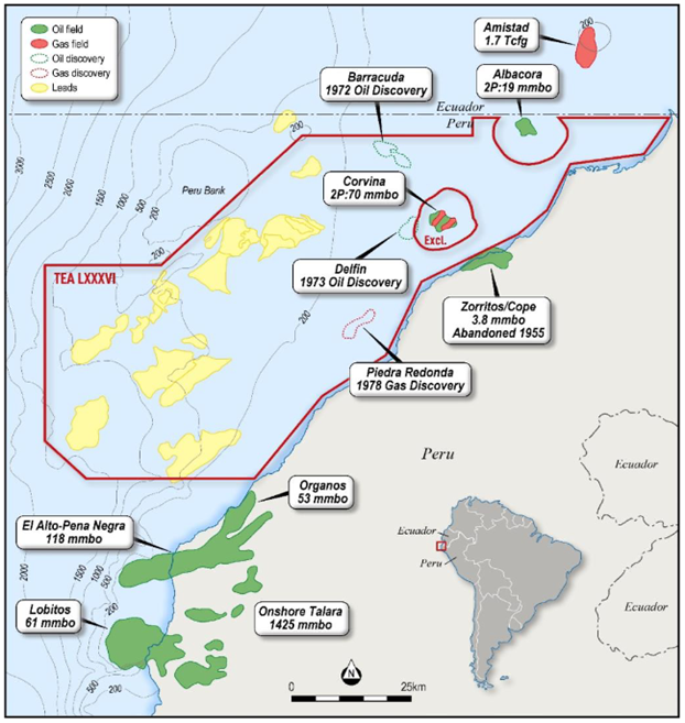
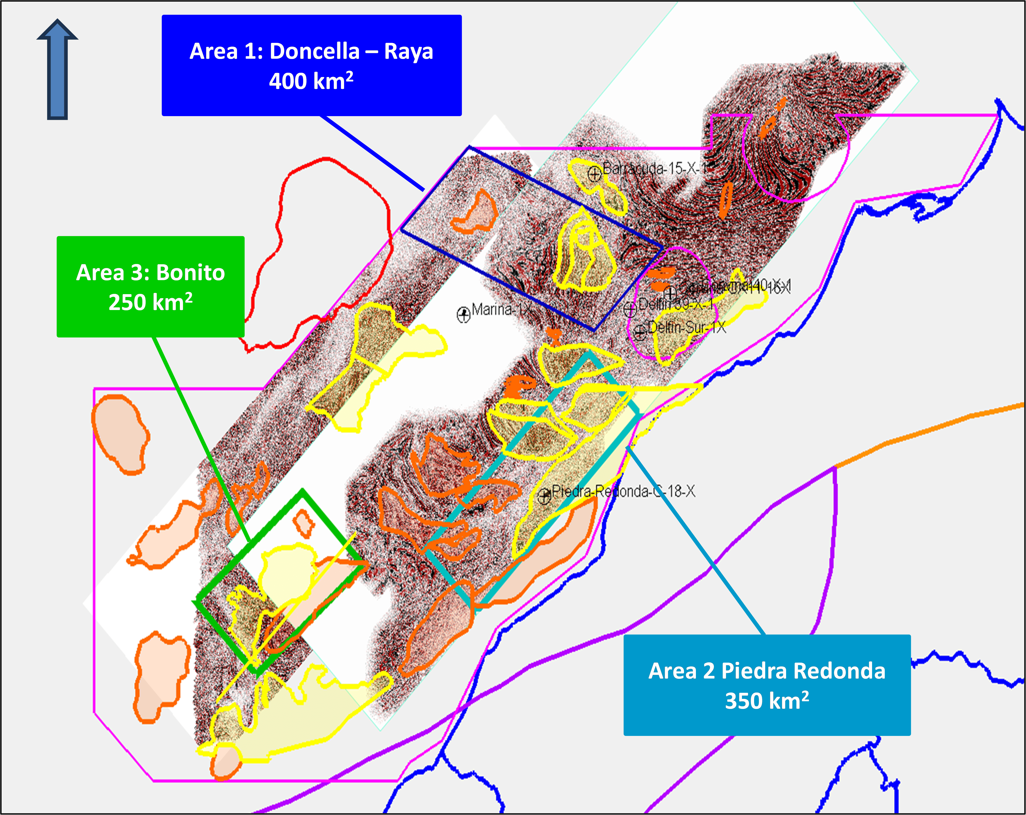
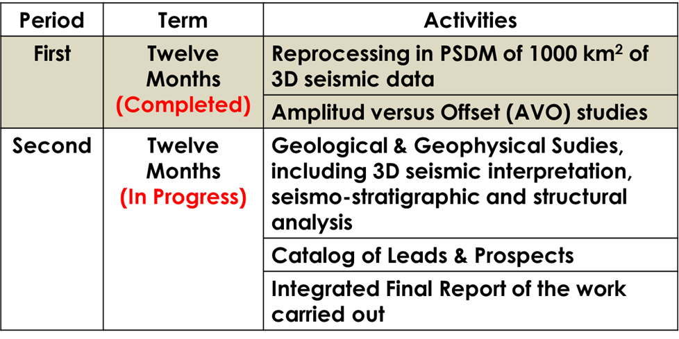
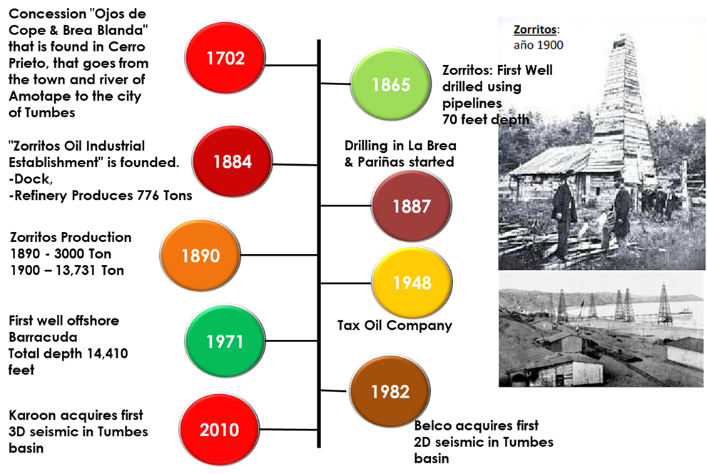
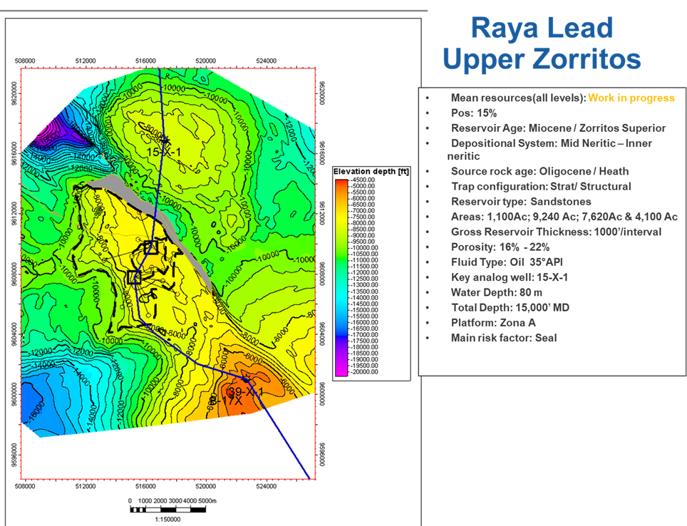
Jaguar Exploration Inc. and its partner Condor Energy Limited have successfully completed advanced geoscience studies for its Technical Evaluation Agreement (TEA LXXXVI) area in the offshore Tumbes Basin in Peru. By accelerating the technical work program and delivering key geological and geophysical results ahead of schedule, the company is strengthening its application for the upcoming License Contract.

The work integrates multiple seismic datasets and interpretation workflows with regional geological information and well data. The study utilized available 3D seismic volumes covering a large portion of the basin together with regional well information to build a robust geological framework for the TEA-86 area.

Figure 1: Seismic attributes and geological interpretation used to define Deepwater turbidite fan systems.

KEY RESULTS – DEEPWATER RESERVOIR SYSTEMS IDENTIFIED

A key uncertainty in the exploration portfolio has been the presence and distribution of deepwater reservoir facies across the identified prospects. To address this, Jaguar has undertaken an integrated technical programmed combining advanced seismic attribute analysis with geological and geophysical studies.

This work has identified basin-scale sediment transport systems and deepwater fan-style depositional geometries across TEA-86, interpreted as turbidite reservoir systems (Figure 1). Importantly, these depositional fairways extend across areas containing the Company’s existing exploration prospects, supporting the presence of sand-rich reservoirs directly overlying mature source rocks.

The identification of these depositional systems significantly reduces a key exploration uncertainty relating to reservoir presence and distribution across the portfolio.

Figure 2 – Seismic attribute mapping delineating feeder channels and basin floor fan systems, supporting the presence of sand-rich reservoir targets

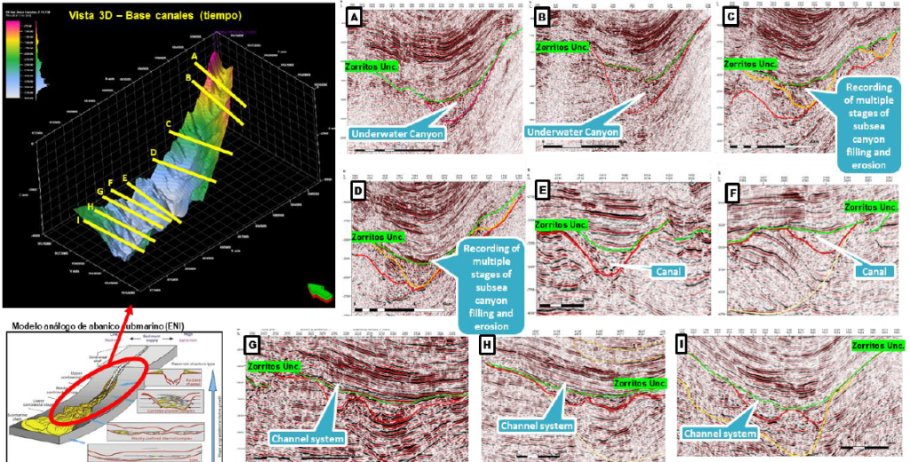
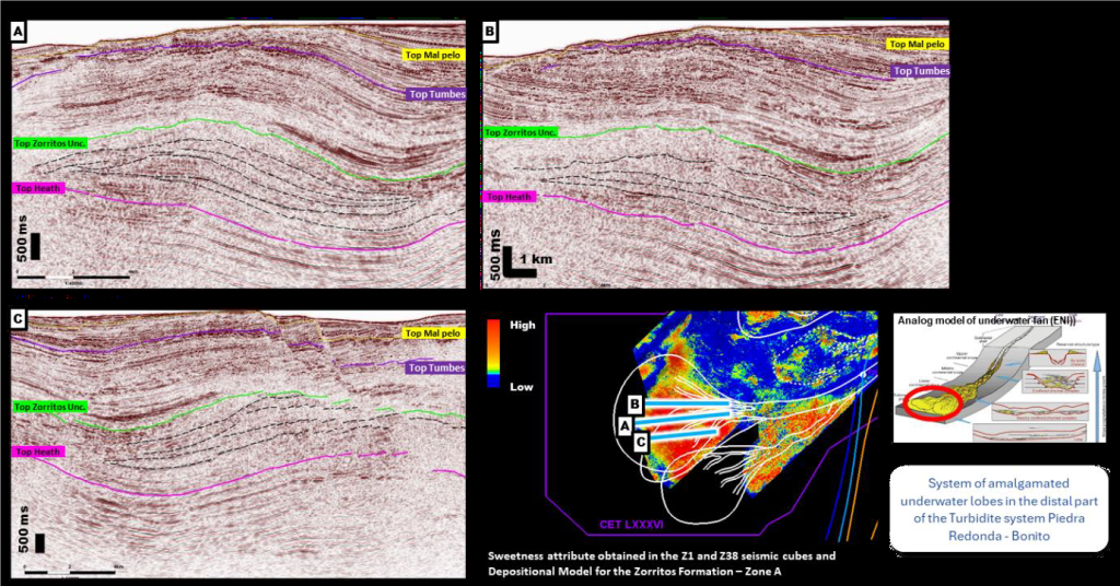
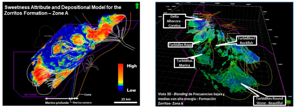
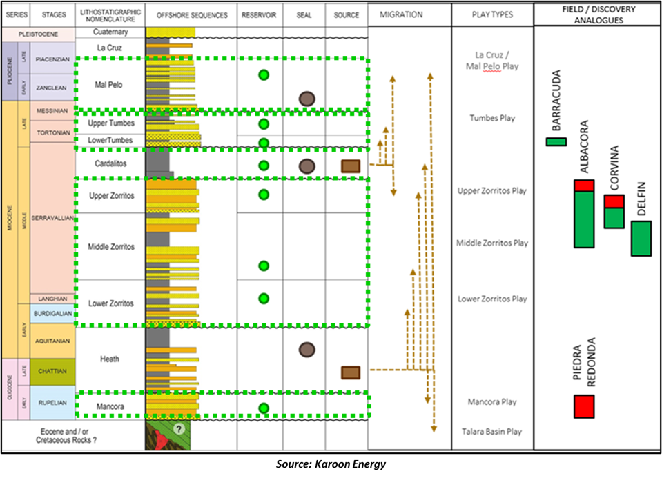
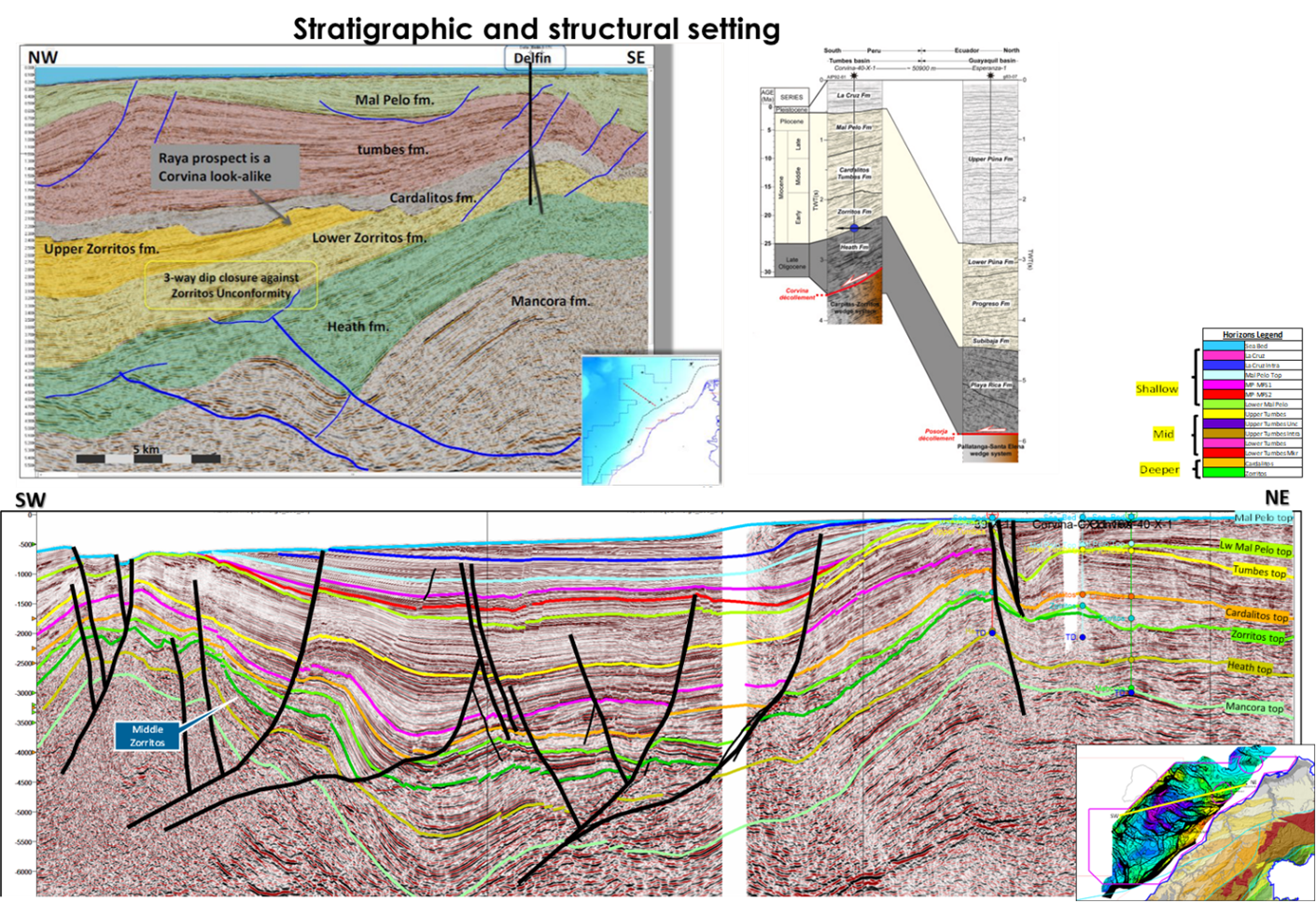
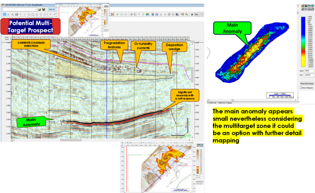
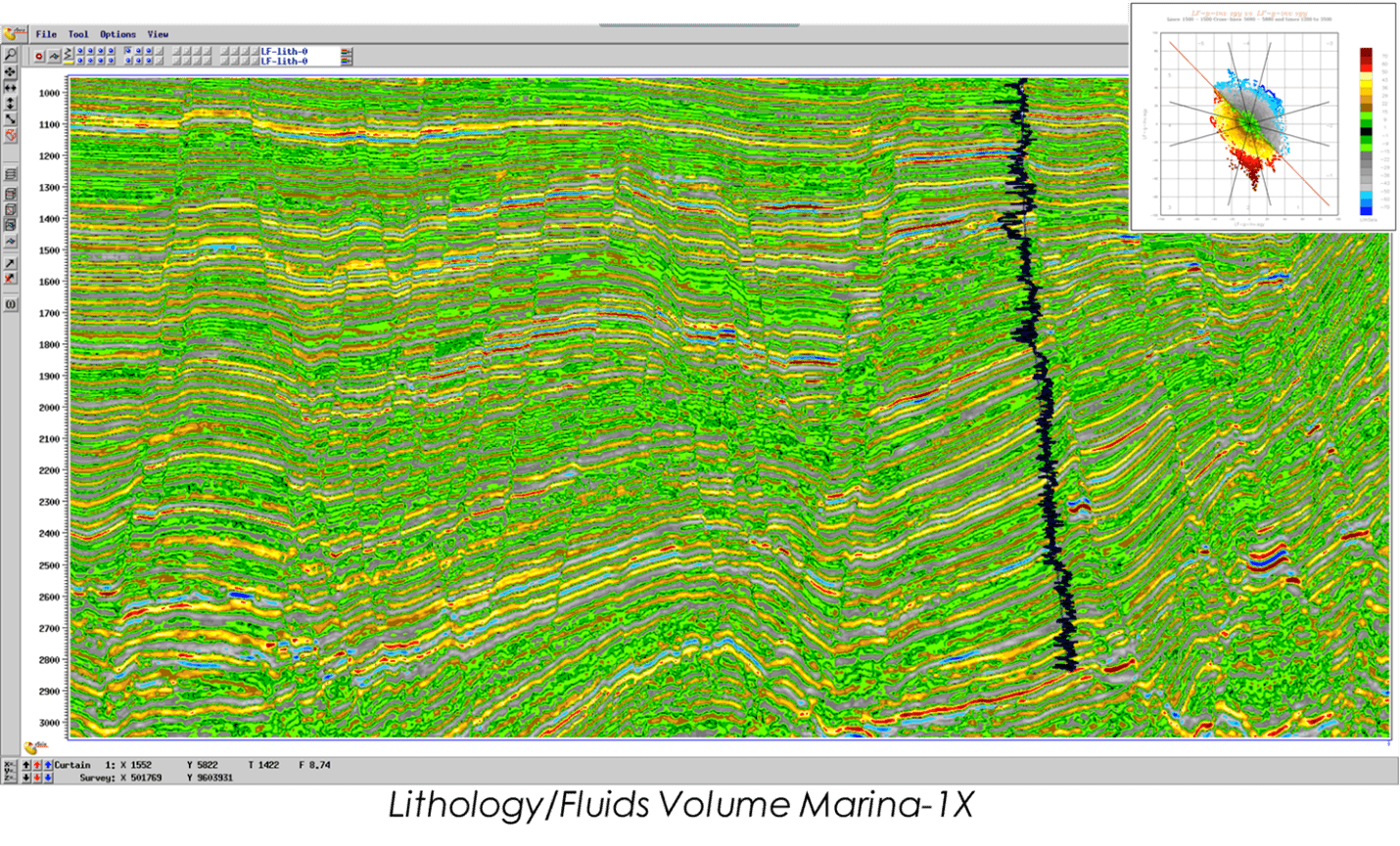
The integrated interpretation incorporated several advanced seismic analysis techniques including (Figure 2):

▪ seismic attribute analysis
▪ amplitude versus offset (AVO) analysis
▪ seismic facies interpretation
▪ regional geological and well calibration

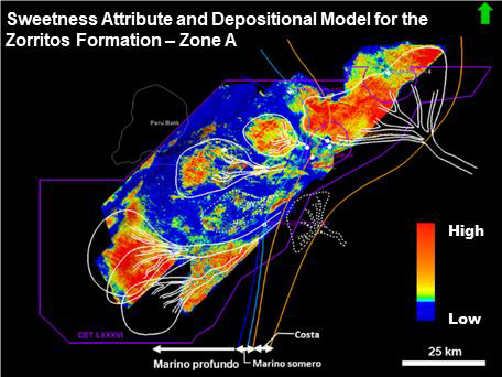
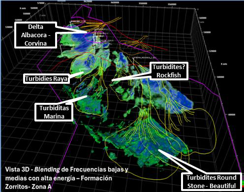
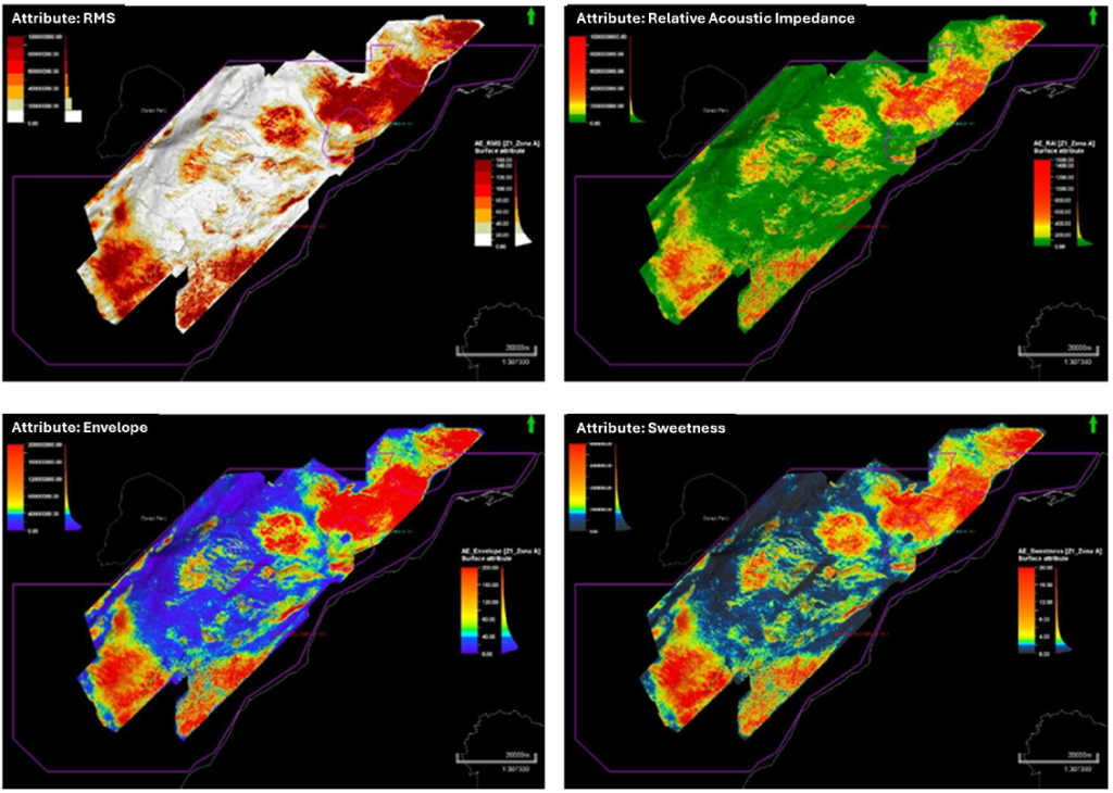
By combining seismic attributes, geological interpretation and regional well calibration,
the studies provide improved understanding of reservoir distribution, depositional architecture and petroleum system elements across the TEA-86 area.

The analysis focused primarily on the Miocene Zorritos Formation, the principal exploration target, while also evaluating the Tumbes and Mal Pelo formations as secondary reservoir intervals.

Interpretation of seismic facies and reflector geometries across the basin indicates the presence of extensive sediment transport systems delivering sand-rich material from shelf and slope environments into deeper parts of the basin.

Seismic geomorphology and depositional modelling highlight channel geometries (see Figure 3), as well as fan-shaped depositional geometries interpreted as deepwater sediment fan systems (see Figure 4 and Figure 5a and 5b). These fan systems appear to form laterally extensive sand-rich bodies deposited by gravity-driven sediment flows along the continental slope and basin floor.

Figure 3: A combination of attribute analysis and seismic interpretation has been used to identify feeder canyons and channel systems, which transport sediment into the deepwater basin.

Figure 4: Beyond the confines of the intra-slope canyons the sediments spill out into basin-floor sands. This is in the classic style of turbidite deposition, and these sands can provide laterally extensive reservoir bodies which due to winnowing and reworking often have enhanced reservoir characteristics as compared to sequences of the same age in shallower water. – Zorritos Formation – Turbidite Piedra Redonda – Bonito.

Figure 5a: Various combinations of attributes and geological interpretation are used to generate depositional models.

Fm Zorritos: Zone A, Deposicional Model.

Figure 5b: Depositional model showing sediment transport from shelf to basin floor forming basin-scale fan systems across Condor’s prospects- of the Zorritos Formation upper interval extraction.

The under-explored block is surrounded by multiple historic and currently producing oil and gas fields and contains the undeveloped shallow water Piedra Redonda gas field which contains ‘Best Estimate’ Contingent Resources of 1 Tcf (100% gross) of natural gas. Exploration is a major focus, with NSAI performing an independent resource assessment confirming multibillion barrel potential, with a combined best estimate gross unrisked 2U prospective resource of 3 billion barrels of oil (.667 billion barrels net to Jaguar) cross the Bonito, Raya, Salmon, Caballa and Tiburon prospect areas. In addition, Jaguar has identified the Raya West prospect, increasing the Company’s total best estimate prospective resource base to over 3.3 billion barrels (gross).

Including the internally estimated Raya West Prospect, the total best estimate unrisked 2U Prospective Resources now exceed 3.3 billion barrels (0.667 billion barrels net to Jaguar).

TEA LXXXVI, Leads & Prospects with Independent estimate of prospective resources across five prospects shown in orange, Raya, Salmon, Bonito, Caballa and Tiburon. Raya West estimate performed by Jaguar. Piedra Redonda gas discovery shown in red.

Prospect

Best Estimate (2U) MMBO

 (Gross) GCoS

Bonito

1007

28%

Raya

575

32%

Raya West*

341

32%

Tiburon

565

17%

Caballa

524

22%

Salmon

362

22%

Total

3,374


 Net (20%) to Jaguar

674


Reservoirs: Primary target Zorritos Formation, with proven discoveries within the block.

Tea block LXXXVI Offshore Peru

Exploring One of South America’s Pacific Offshore Basin with World-Class Hydrocarbon

In August 2023 Jaguar Exploration, Inc. (Jaguar) with its partner Condor Energy Limited (Condor), entered into the 4,858 km2 Technical Evaluation Agreement (TEA) offshore Peru with Perupetro. The TEA area covers almost all the Peruvian offshore Tumbes Basin in moderate water depths of between 50m to 1,500m. The block is surrounded by, and incorporates, multiple historic and currently producing oil and gas fields.

The TEA provides Condor and Jaguar with a two-year exclusive option (with the possibility of a further one-year extension) to convert all or part of the expansive TEA area into one or more License Contracts.

Jaguar Exploration is the technical advisor and manages the TEA project.

Strategy

  • Jaguar Exploration Inc, and its JV partners, Condor Energy Ltd, have designed a multi-disciplinary work program to rapidly assess the petroleum prospectivity of the Tumbes Basin. 
  • There are many prospective features across the whole 3D seismic volume and some features outside the 3D which are mapped on 2D seismic. 
  • The portfolio will be high-graded and risked before being audited by independent reserve auditors. 
  • The JV will seek to farm-down some interest in the project before converting the TEA into a conventional exploration contract.
  •  The primary objective is to drill one or more wells to test the oil potential in some of the undrilled prospects high-graded by the technical study.
  •  The secondary objective is to determine the feasibility of a gas-to-power project based on the development of the Piedra Redonda gas field.

Work Program Commitment

During the first year of the TEA execution the Reprocessing in PSDM of 1,000 km2 of 3D Seismic Data and Amplitude vs. Offset Studies have been completed.

Type:                         TEA

JV:                              80% Global 20% Jaguar

Formalization:         Aug/10th/2023

Term:                         Two years

Expiry Date:             Aug/2025

Area:                          4858 km2

Seismic in Block:     7,272 km of 2D

                                    3,639 km2 of 3D PSTM

                                    358 km (PSTM/PSDM)

Water depth:            50 – 1500 m

Wells in Block:         >12 and surrounded discoveries

Geology:                  Tertiary

Play:                          Structural-Stratigraphic 

Tumbes Basing Data & History

Regional setting & Interpretation

The Oligocene to Recent Tumbes (Peru)/Progreso (Ecuador) Basin is Peru’s most northern, predominantly offshore basin. It is an assemblage of sub-basins locally enclosed by the Chongon-Colonche Hills (Cretaceous Piñon Formation) to the north, an accretionary complex to the west, and the Andes Mountains and Amotape Range (Precambrian and Paleozoic metamorphic terrane) in the east and southeast.

Stratigraphic Column of the Tumbes Basin

Raya Lead

STRATIGRAPHIC APPROACH

For many years the Tumbes Basin has been regarded by many Operators as a prospective Structural play zone, however it is quite evident that a stratigraphic play exists in this Basin, and it is a question of finding the right trap at a reasonable depth to prove it.

We believe that this will have a positive impact in the search for hydrocarbons and the overall prospectivity of the basin.

We also believe that with further detailed study and using better seismic data it will be possible to detect better these geo-bodies despite some of them being disturbed by the complexity of the geology in this active margin. 

SALMONETE LEAD

AVO & INVERSION STUDIES

Houston based consultants eSeis Inc conducted pre-stack processing of the 3D seismic volumes, using their proprietary LithSeis technology, to produce a Lithology/Fluid volume and an Amplitude Versus Offset (AVO) volume.